Key Highlights:
- Google’s updated Perch 2.0 AI model listens to nature sounds to detect and track species across diverse habitats.
- The AlphaEarth mapping system uses AI and Graph Neural Networks to map global biodiversity and predict species ranges.
- Google’s deforestation risk model predicts forest loss with high precision, helping policymakers take preventive action.
Google has been at the front and center of the AI industry ever since the technology became a talking term in every household. Now, AI giants, like Google and others, have multiple responsibilities on their hands. Although Google is known mostly for its consumer-facing products, the company has now turned its focus towards nature, which I think is need of the hour. As they say nature has its own voice, from rustles of trees in a forest to canopy hums and hidden chatter of birds, frogs, and insects. Now imagine an AI that can hear all of it, and helps us understand what it means for the planet’s health. Well, that’s exactly what Google’s trying to do.
Perch 2.0 AI model listens to nature sounds and track endangered species in their habitat
The company’s ecosystem modeling team and DeepMind have launched many AI models designed to map, monitor, and protect nature. From identifying endangered birds to predicting where deforestation might strike next, these models can help policy makers understand nature in a smarter way.
Google is trying to achieve that with “Perch 2.0.” which it calls an upgraded AI model that listens to nature’s sounds to detect and track species across diverse habitats. Google says that the model “is not only state-of-the-art for bird identification, but also available as a foundational model.” In other words, scientists can improve the model for new species and ecosystems without needing to start from scratch.
The updated version of Perch, available openly on Kaggle, can now process bioacoustic data from coral reefs, rainforests, and wetlands. This eventually gives conservationists a new, smarter way to interpret massive amounts of field audio. However, listening to audios isn’t the only piece scientists have to solve. That’s where Google’s latest work on developing AI-powered mapping is necessary.
AI is mapping the Earth’s living blueprint
As detailed by Google in its recent DeepMind blog, a team of researchers are working on a mapping system powered by AI. And it can change how we, humans, see biodiversity on a planetary scale. Google’s in-house AI model are using Graph Neural Networks (GNNs) to understand what’s there on the ground. Additionally, with the satellite data from AlphaEarth Foundations, the models are making researchers understand species traits like body mass to predict species ranges worldwide.
What’s interesting is that this model helps to find out where animals live. This is handy because the team can pull data even from places where direct data is scarce. As part of a pilot program with QCIF and EcoCommons, Google has already mapped the distribution of Australian mammals like the Greater Glider, a nocturnal marsupial that depends on old-growth eucalyptus forests.
At present, Google has made 23 of these range maps publicly available through the UN Biodiversity Lab. The company says that these range maps offer scientists and policymakers invaluable insights to track and protect endangered wildlife species. In other words, AI isn’t just tracking species; it’s helping us understand how ecosystems shift, respond, and sometimes collapse under human pressure.
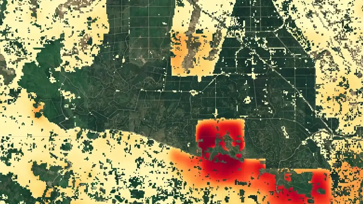
Deforestation prediction before it happens
We all are aware deforestation is one of the biggest threats to the planet. Why? Well, that’s because forests store carbon, regulate climate, and are home to Earth’s biodiversity. Google understands this quite well, and has partnered with the World Resources Institute (WRI) for satellite tracking to understand why deforestation actually happens.
Their deforestation risk model, that spans across 2000–2024, figures out main reasons, that ranges from agriculture, logging, mining, and fire. That too, at an unprecedented 1 km² resolution. This AI model uses only satellite inputs to predict where forest loss is most likely to happen, that too with 30-meter precision. In short, this could help governments and NGOs to understand the risk factors and react to deforestation in a planned manner.
With all the aforementioned models, Perch 2.0, AlphaEarth, and the deforestation predictors, Google wants policymakers to understand not just where the biosphere is changing, but why. All that said, it’s one of Google’s visions to prevent ecosystems and biodiversity from collapsing. After all, it will impact us, humans, and that too in a pretty harsh way.
What do you think about all the efforts Google is making in respect to nature? Drop your thoughts below, we’d be happy to hear what you think. What else can be done by these tech giants to help us understand mother nature better?